Thailand has some of the best driving roads in Southeast Asia. The northern mountains around Chiang Mai and Nan offer hundreds of kilometers of smooth, twisting asphalt with almost no traffic. The south has coastal routes along the Andaman Sea with limestone cliffs and ocean views.
Here are the 10 best driving roads in Thailand, from half day loops to multi day adventures.
Contents
- 1 Quick Summary
- 2 Route 1148 (Nan to Phayao)
- 3 Mae Hong Son Loop
- 4 Samoeng Loop (Chiang Mai)
- 5 Doi Inthanon (Route 1009)
- 6 Khao Yai National Park
- 7 Bangkok to Pattaya Motorway
- 8 Krabi to Phang Nga Coastal Road
- 9 Samet Nangshe Viewpoint Road
- 10 Koh Lanta Coastal Loop
- 11 Bangkok to Khao Yai (Highway 2090)
- 12 When to Drive
- 13 Practical Tips for Driving in Thailand
- 14 Renn Driver's Take
- 15 FAQ
Quick Summary
Thailand's best driving roads sit in two regions. The northern mountains around Chiang Mai, Nan, and Mae Hong Son have smooth, twisting hill roads with elevation changes, blind crests, and virtually empty lanes. The southern Andaman coast has scenic coastal routes with limestone karst backdrops and ocean views. Bangkok itself is a traffic nightmare, but fast motorways connect it to the good stuff within two hours.
| Road | Region | Distance | Character |
|---|---|---|---|
| Route 1148 | Nan / Phayao | 91 km | Mountain switchbacks, zero traffic |
| Mae Hong Son Loop | Chiang Mai | 600 km | 1,864 curves, multi day |
| Samoeng Loop | Chiang Mai | 100 km | Half day mountain loop |
| Doi Inthanon | Chiang Mai | 48 km | Climb to Thailand's highest point |
| Khao Yai | Nakhon Ratchasima | 50 km | Rolling hills through jungle |
| Bangkok to Pattaya | Central | 150 km | Fast dual carriageway |
| Krabi to Phang Nga | Andaman Coast | 140 km | Coastal limestone scenery |
| Samet Nangshe | Phang Nga | 6 km | Short hill climb, bay views |
| Koh Lanta | Krabi | 30 km | Island coastal road |
| Highway 2090 | Central | 30 km | Forest road to Khao Yai |
Route 1148 (Nan to Phayao)
Route 1148 is the single best driving road in Thailand. It connects Tha Wang Pha in Nan province to Chiang Kham in Phayao province across 91 km of unbroken mountain terrain. The asphalt is smooth and well cambered. The corners are constant. The elevation shifts every few minutes. On most days, there is no traffic at all.
What makes 1148 special is the total absence of interruptions. There are no villages, no intersections, no traffic lights, and no commercial trucks for the entire 91 km stretch. You drive from one end to the other with nothing but mountain jungle on both sides and clean tarmac ahead. International touring publications have ranked it among the top 10 motorcycle roads in the world, but it works just as well in a car.
The drive takes two to three hours at a safe and enjoyable pace. There is no fuel between the start and end points, so fill up before you set off. The nearest airports are Nan Nakhon (to the south) and Chiang Rai (to the north). From Chiang Mai, budget about three hours to reach the start of 1148 at Tha Wang Pha.
Mae Hong Son Loop
The Mae Hong Son Loop is Thailand's most famous driving route. It is a roughly 600 km circuit through the mountains west of Chiang Mai, passing through Pai, Mae Hong Son town, and Mae Sariang (or Mae Chaem on the alternative return). The loop contains a catalogued 1,864 curves between Chiang Mai and Mae Hong Son town alone.
The route follows several highways. Route 1095 runs from Chiang Mai to Pai (135 km) and onward to Mae Hong Son (110 km). Route 108 heads south through Khun Yuam to Mae Sariang. The return to Chiang Mai can go via Highway 108 through Hot, or via Route 1009 over Doi Inthanon for an even more dramatic finish.
Most people allow four to six days for the full loop. The roads are entirely paved and passable by any standard car in dry season. During monsoon months (July through October), check conditions before departing because landslides can occasionally block sections. Fuel stations appear in every town, and the longest gap between them rarely exceeds 50 km.
Samoeng Loop (Chiang Mai)
The Samoeng Loop is the best half day drive near Chiang Mai. It is a 100 km circuit through the mountains northwest of the city, with roughly 1,500 meters of total elevation gain. The loop is popular with cyclists and motorcyclists, but the wide, well surfaced road works perfectly for cars.
The highlight section is Route 1269, which includes a famously steep stretch known as the "seven hairpins" that covers 2.3 km at an average gradient of 12%, maxing out at 17%. The road climbs through villages and farms before ascending to the Krista Doi Pass at 830 meters above sea level. Views open up across layered mountain ridges and forested valleys.
The full loop takes about three hours of driving without stops. With coffee breaks and viewpoints, budget a full morning or afternoon. Fuel up in Chiang Mai before departure. The best months are November through February when the air is cool and the mountains are green. This is an excellent warm up drive before committing to the Mae Hong Son Loop.
Doi Inthanon (Route 1009)
Route 1009 climbs 48 km from the town of Chom Thong to the summit of Doi Inthanon, the highest point in Thailand at 2,565 meters above sea level. The road has an average gradient of about 9.5% and is fully paved, wide, and well maintained. The drive to the top takes approximately 45 minutes.
The appeal of Doi Inthanon is not the corners (the road is not as twisty as 1148 or the Samoeng Loop) but the altitude. Temperatures at the summit can be 10 to 15 degrees cooler than Chiang Mai, and during the cool season (December through February), it occasionally drops close to freezing. If you are driving in Thailand's heat, the chance to open the windows to genuinely cold mountain air is worth the trip alone.
To reach Chom Thong, take Highway 108 southwest from Chiang Mai for 58 km. Doi Inthanon can be combined with the Samoeng Loop for a full day of driving, or folded into the return leg of the Mae Hong Son Loop via Mae Chaem.
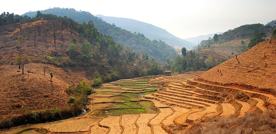
Khao Yai National Park
Khao Yai is the closest good driving destination to Bangkok, and one of the best weekend road trips from the capital. The national park sits about 180 km northeast of the capital in Nakhon Ratchasima province. The drive from Bangkok takes roughly 2.5 hours, most of it on fast highways before the road climbs into the park's rolling hills and dense forest canopy.
Thanarat Road winds approximately 50 km through the park. The road is sealed, in good condition, and cuts through thick jungle with elevation changes and sweeping curves. Wildlife crossings mean you need to watch for monkeys, deer, and the occasional elephant near the road. Speed inside the park is limited, but the setting and the road surface make it enjoyable at any pace.
Khao Yai is popular with the Bangkok car community for weekend drives. The Highway 1016 strip leading to the park entrance is lined with cafes, restaurants, and scenic viewpoints. Many drivers make Khao Yai a day trip, combining the park drive with lunch at one of the hilltop restaurants along the approach road.
Bangkok to Pattaya Motorway
The Bangkok to Pattaya motorway (Highway 7) is not scenic, but it is the fastest, smoothest road in Thailand. The 150 km dual carriageway connects Suvarnabhumi Airport to Pattaya with minimal traffic, a high speed limit (120 km/h, lightly enforced), and excellent tarmac. If you want to stretch a car's legs on a straight, open road, this is the place.
The motorway is toll based. An Easy Pass RFID transponder saves time at the booths and is accepted across Bangkok's expressway network. The drive takes about 90 minutes at legal speeds. At the Pattaya end, you are close to Bira International Circuit, where regular track days offer a proper outlet for speed. Combine the motorway blast with a track session for a full day out of Bangkok.
Krabi to Phang Nga Coastal Road
The 140 km drive from Krabi to Phang Nga along Route 4 is the best coastal road in Thailand. The highway runs through southern Thailand's Andaman coast, with limestone cliffs rising from mangrove forests, views of the turquoise Andaman Sea, and small fishing towns breaking up the scenery at regular intervals.
The road itself is well paved with clear signage and plenty of rest stops. It does not have the twists and elevation of the northern mountain roads, but the landscape more than compensates. Key stops along the way include Ao Thalane (kayaking through mangroves), Wat Suwan Kuha (a temple inside a cave), and the approach to Phang Nga Bay with its dramatic karst formations.
The best time for this drive is November through April when the Andaman coast is dry and the skies are clear. During monsoon season (May through October), heavy rain and reduced visibility can take the edge off the experience.
Samet Nangshe Viewpoint Road
Samet Nangshe is a short but rewarding hill climb near the Andaman coast in Phang Nga province. The road is only about 6 km long, twisting up a limestone karst to a viewpoint overlooking Phang Nga Bay. At sunrise, the view across the bay's dozens of karst islands is one of the most photographed scenes in southern Thailand.
The road is narrow in places, so go early to avoid oncoming traffic. It can be combined with the Krabi to Phang Nga coastal drive for a full day of southern Thailand driving. The viewpoint has a small parking area and a short walking trail to the top.
Koh Lanta Coastal Loop
Koh Lanta is a quiet island off the coast of Krabi with roughly 30 km of coastal roads that offer minimal traffic and views of the Andaman Sea. The main road runs the length of the island's west coast, passing a string of beaches. A loop around the southern end takes you through rubber plantations and mangrove forest before dropping back to the coast.
This is not a technical driving road. The appeal is the setting: tropical ocean on one side, jungle on the other, and almost nobody else on the road. For a relaxed cruise after a day of the tighter mountain roads in the north, Koh Lanta delivers. Access is via a short car ferry from the mainland.
Bangkok to Khao Yai (Highway 2090)
Highway 2090 is the final 30 km approach road to Khao Yai National Park from the lowlands. It climbs from the plains near Pak Chong through increasingly dense forest, with elevation changes and a series of curves that signal you are leaving the flatness of central Thailand behind. The road is well maintained and wide enough for confident driving.
This section is best driven as part of the full Bangkok to Khao Yai trip. After two hours of flat motorway from the capital, Highway 2090 is where the road starts to get interesting. It is also the stretch where you are most likely to see wildlife, including monkeys sitting on the road shoulders and the occasional larger animal crossing at dusk.
When to Drive
The cool season (November through February) is the best time for driving in Thailand. Temperatures in the northern mountains drop to a comfortable 15 to 25 degrees Celsius during the day. The air is clear, visibility is excellent, and the roads are dry. This is peak season for all the routes listed above.
The hot season (March through May) brings temperatures of 35 to 40 degrees Celsius in the lowlands. Mountain roads are still enjoyable because the altitude provides relief, but the haze from agricultural burning can reduce visibility across the north during March and April.
The monsoon season (June through October) brings heavy rain, particularly in the south and along the Gulf coast. Northern roads can be affected by landslides. Driving is still possible, but conditions are less predictable. Avoid low clearance cars on rural roads during heavy rain, and never drive through standing water. For more on seasonal conditions and what to expect on Thai roads, see our Thailand Porsche guide.
Practical Tips for Driving in Thailand
Thailand drives on the left. If you are coming from a country that drives on the right, the adjustment takes a day or two. Roundabouts flow clockwise, and right turns cross oncoming traffic. U turn lanes are used instead of direct left turns at many intersections.
Fuel is widely available. Benzin 95 (95 octane, no ethanol) is the best option for performance cars. Shell and PTT stations are the most reliable for premium fuel quality. In remote mountain areas, plan your fuel stops because the gap between stations can reach 40 to 50 km.
Speed limits are 90 km/h on highways, 80 km/h on rural roads, and 50 km/h in urban areas. Enforcement is inconsistent but speed cameras do exist on major routes. The real hazards are not the police but the unmarked speed bumps, stray dogs on warm asphalt, and motorcycles driving against traffic on the shoulder.
A valid Thai driver's license or International Driving Permit is required. If you are renting a car, agencies in Chiang Mai and Bangkok offer everything from compact sedans to SUVs. For the mountain roads, an SUV or crossover with decent ground clearance handles the occasional pothole and steep gradient more comfortably than a lowered sports car. If you are bringing your own car, check our guide to car insurance in Thailand before heading out.
For track driving and motorsport, the mountain roads are public highways with real hazards. Save the flat out driving for a circuit.
Renn Driver's Take
I have not driven this car yet. When I do, this section will have my honest take on what it is actually like to live with and drive.
FAQ
What is the best driving road in Thailand?
Route 1148 between Nan and Phayao is the best driving road in Thailand. It covers 91 km of smooth, twisting mountain tarmac with no traffic, no villages, and no interruptions. International touring publications rank it among the top 10 motorcycle and driving roads in the world.
Is Thailand good for road trips?
Thailand is excellent for road trips. The main highways are well maintained, fuel is widely available, and the northern mountains offer some of the best driving roads in Southeast Asia. The Mae Hong Son Loop (600 km, 1,864 curves) is one of the most popular multi day driving routes in the region.
Can you drive from Bangkok to Chiang Mai?
The drive from Bangkok to Chiang Mai covers roughly 700 km and takes 8 to 10 hours on Highway 1 and Highway 11. The road passes through Ayutthaya, Nakhon Sawan, and Lampang. Most of the route is flat dual carriageway, with the scenery improving significantly in the final two hours as the road enters the northern hills.
What side of the road do you drive on in Thailand?
Thailand drives on the left side of the road, with right hand drive cars (steering wheel on the right). This is the same system used in the UK, Japan, and Australia. Most drivers coming from right hand drive countries adjust within a day or two.
Do you need a license to drive in Thailand?
You need either a valid Thai driver's license or an International Driving Permit (IDP) to drive legally in Thailand. Your home country license alone is not sufficient. An IDP can be obtained before travel from your country's automobile association.